Inca Trail – Part 1
The Inca Trail is a very popular hiking trip in the Andes of Peru. It is rated among the 10 best trekking trails in the world due to the different ecological areas from the high Andean plains to the cloud forest. Not to speak of the gorgeous views from the various passes that are conquered and the ruins encountered. It is an amazing adventure into the the history of the grand Inca civilisation.
First discovered in 1911
The 45 km long Inca Trail was first discovered and explored by Hiram Bingham in 1911.Albeit, what is known of the Inca Trail today is only a short stretch of a vast network of Inca roads through the country. It was first opened to the public in 1970.
There are different routes and length to the Inca Trail. The one I had chosen consisted in three nights in a tent and four days hiking.Tour companies differ in their choice of e.g. campsites.
Three days of acclimatisation in Cusco
I spent three days in Cusco at about 3400 metres. This would help me with the acclimatisation to the altitude. I would recommend to everybody to do this.
Cusco is the archaeological capital of the Americas. It presents massive walls, cobblestone streets and the remnants of the Inca empire and the Spanish colonial period. So definitely worth a visit. I am not getting any further into this as it merits a post on its own.

We first have to get to the Sacred Valley
I and the rest of the group were picked up early in the morning in Cusco. After some 2 hours drive constantly descending through an amazing scenery, we arrived in Ollantaytambo, an original Inca village situated near the Urubamba river.

Great place to visit
By the way, this is a nice place to visit albeit after the hordes of Inca Trail hikers have left it later in the morning. There is a massive Inca fortress on a nearby hillside to check out. Or simply wander through the cobblestoned streets of the old town consisting of adobe buildings.
After a short visit we then boarded the bus again and arrived at Kilometre 82 an hour later.
Piscacucho – the Inca Trail begins here
Some refer to this spot as Km 82. As this is as far as the road goes it makes it the natural starting point for the Inca Trail. By the way, km 82 marks the distance between Cusco and Machu Picchu.
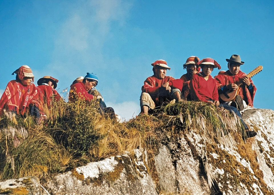
Meet our porters of the Inca Trail
Here we met our porters and other support staff. After a light lunch we were off for our adventure.

First of four checkpoints
After going through a check point where our entrance tickets were collected and passports checked we were off.

The first few kilometres of the hike flanked the Urubamba River and were on relatively flat terrain.
However, the trail soon began to gain elevation quite rapidly preparing us for what was to come in the following days.
During the three hours “warming up hike” (as I would call it) we passed a number of villages and settlements where we could buy some water and interact with the locals.
Guides at the head and the tail of the group
I noticed that one guide would always be in front with the fastest hikers whilst another one at the very end to make sure that nobody gets left behind. This was very reassuring as hikers obviously walked on their own pace.
1st Camp – Llaqtapata ruins
Eventually, we reached the Llaqtapata ruins were we would spend the first night at an altitude of around 2700 metres.
It was incredible that the tents were already pitched and we got some warm water to freshen up a bit before dinner. The fact that a warm meal was served considering that everything (and I mean everything) needed to be carried along is really quiet amazing.

Next morning we had time to visit the ruins before continuing. This was followed by a nice hike passing through a number of small villages. The path was flanking the Kusichaca river.
Last village of the Inca Trail
Finally, we reached Wayllabamba, a quit village of Inca origins and the last settlement we would encounter during our hike.


From here on the trek was a gradual albeit continued ascent. In fact, we climbed some 1800 metres and began to enter the cloud forest.

2nd Camp – Llulluchapampa around 3800 meters
Finally we reached our second camp at 3800 metres of altitude. I guess, I can say we were all somewhat tired. However, we all knew that the hardest part of the Inca Trail was going to be first thing tomorrow morning ascending the 535 vertical metres at this altitude.
1st pass – Warmiwanusca at 4200 metres
Very early in the morning we started the seemingly never-ending haul up to the pass also called Dead Woman Pass. It was given this peculiar name as apparently it resembles a dead woman lying on her back. To be honest, I could not really see her.
Most strenuous ascent during the Inca Trail
As already mentioned, the 2nd day is the most challenging and brutal one of the Inca Trail. For me the only way to do the ascent was to move slowly but steadily with not to many stops in between. It took me about two hours to get to the top.
A well deserved rest was on the program during which we could admire the fantastic view from up there.

But then it was time to move on. A stepped path took us towards the Valley of the Pacamayo River. While the initial part was all downhill it was not that easy to walk on the very uneven and at times slippery stones. That was not the case for locals and Llamas that just strolled along with no difficulty.


This concludes the first part of my story doing the Inca Trail.
Continue reading Part 2 of my experience doing the Inca trail.
Also check out my post on the Inti Raymi and my trip to the floating reed islands on Lake Titicaca near Puno, Peru
Leave A Comment
You must be logged in to post a comment.